


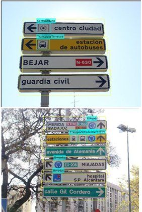
CAMARIA Project
CAMARIA develops a cost-effective predictive maintenance tool, based on 3D cameras mounted on road surveillance vehicles, and AI modules to detect deficiencies in the road surface and identify road signs.
Learn from visual inputs to estimate future road degradation and create an up-to-date inventory of each type of traffic sign using a hierarchical approach.

e-Miles electric car

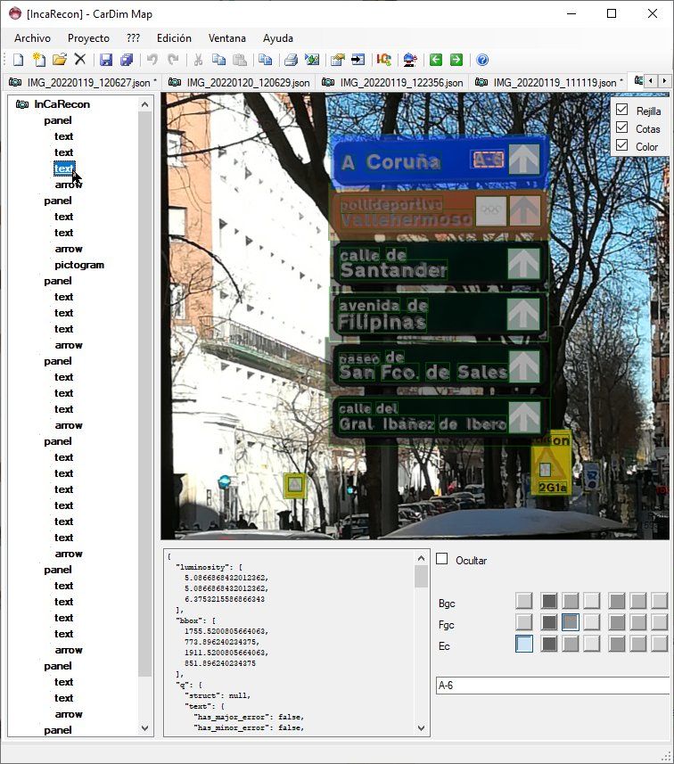
InCa RECON Project


APPARCCO Project


Urbanet Project

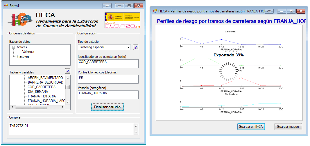
HECA application
The HECA application is an Accident Cause Extraction Tool that allows for the generation of accurate accident models based on historical records. This application is launched directly from the InCa interface and enables various analyses of the accident data stored in the database.

Descriptive Analysis of HECA
These are basic statistical analyses of all the data or filtered sets of data: bar charts and joint distribution of variables. These tools allow for a simple visual analysis of the different variables involved in accidents.

Overrepresentation
It allows you to detect problems that in most cases could be solved by applying some type of control measure: increased safety measures, modification of road layouts, implementation of breathalyzer tests, etc. A simple example is alcohol: according to the analyzed data, Saturdays and Sundays are overrepresented in terms of accidents involving alcohol. Many other analyses are possible with this intuitive and powerful tool. Further explanation: the calculation is simple. In the example, if 20% of accidents without alcohol occur on weekends, but 40% of accidents involving alcohol occur on those same days, then alcohol is overrepresented by a factor of 40%/20% = 2 on weekends.

Maximum Profit
Given the overrepresentation of a risk factor, it's worth asking what the maximum number of accidents could be if a control measure were implemented to prevent it. This number is called the maximum gain, and it allows for a cost-benefit analysis of the design of countermeasures to be applied to reduce the factor. Further explanation: in the example of alcohol on weekends, it's unlikely that weekend accidents could be reduced by less than 20% (corresponding to the percentage of accidents in the absence of alcohol). More detail: to calculate the maximum gain, we first calculate the minimum number of accidents we could achieve, which corresponds to the percentage of weekend accidents out of all accidents without alcohol (20% in our example) multiplied by the total number of accidents with alcohol present. This number is the lower achievable limit. Therefore, the maximum gain is the number of alcohol-related accidents on weekends (the current situation) minus this lower achievable limit.

Spatial Clustering
The variables involved in a traffic accident have a spatial correlation that allows road segments to be classified according to profiles of these variables. For example, on certain roads, accidents tend to be concentrated in the early morning and afternoon, corresponding to the daily flow of people commuting to and from work, while in other areas, accidents tend to be concentrated in the early hours of weekend mornings. The innovative spatial clustering technique included in HECA allows for the local analysis, i.e., of road segments, of the occurrence of certain variables related to accidents. Each of the road segments considered is subsequently classified according to a typical accident profile. This analysis allows us to answer questions such as: On which segments do the most serious accidents occur? At what time of day and on which segments should we control speed to significantly reduce the number of accidents? Which areas have nighttime accident profiles?
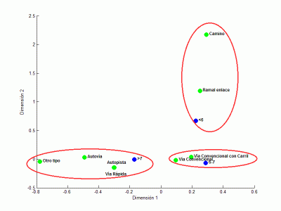
Correspondence Analysis
Correspondence analysis creates a 2D representation of the different values that two variables can have, allowing us to discover relationships between the categories of the analyzed variables. For example, we can find a relationship between the injury severity variable (uninjured, minor, serious, fatal) and the road type variable. This analysis allows us to answer questions such as: What is the relationship between the injury severity of an accident and the time of day? At accident sites, is there a relationship between the road surface condition and the road type?

Georeferencing
All of InCa's statistical tools allow for the georeferencing of each accident in the database. This capability enables the creation of complex thematic maps based on user-selected filters. In this example, we show a thematic map that uses colors to differentiate accidents according to the quarter of the year in which they occurred.